Construction of a longitudinal profile of a gas pipeline. Construction of a longitudinal profile of an underground gas pipeline Methodology for constructing a plan of a longitudinal profile of a gas pipeline
To design a structure of a linear type, a longitudinal profile is built. The profile is built on graph paper and is compiled according to the data
picketing and leveling magazines. The scale of vertical distances on the profile is taken 10 times larger than for horizontal distances.
When compiling a profile, they are guided by a certain layout for placing and recording the necessary data. All initial (and then design data) are entered in column 6. Recommended graph height (from bottom to top) in millimeters: 5, 10.15, 10, 15 and 20mm.
Compilation of a profile (Figure 30) begins with filling the "pickets" column, in which, in accordance with the horizontal scale, the numbers of the pickets are indicated: 0, 1 ... n.
Figure 30. Profile of longitudinal leveling
In the "distances" column, vertical lines denote all pickets and characteristic points of the route. The distances between these straight lines indicate the distances. If there are no plus points between adjacent pickets, then the distances are not recorded. If plus points are available, the distances (in meters) between the rear picket and the first (between pickets) plus point, the distances between plus points and the distance between the last plus point and the front picket are recorded.
For example, for plus points +40 and +80, located between pickets 2 and 3, in the column "distances" you should write 40, 40 and 20 (Figure 30).
In the column "actual marks" are recorded from the leveling log (with rounding to hundredths of meters) marks of pickets and plus points. x dots, which are taken on steep slopes and serve to transfer marks from one tie point to another, are not applied to the profile.
In the columns "slopes / distances" and "design marks" data related to profile design is entered.
Column "route plan" is filled in according to the picket log data. in the middle of the column "track plan" is a straight line representing
a straightened axis of the leveling track - the axis of a linear structure. If the route has turns along its length, then the arrow shows their direction at the turning points. When turning right, the arrow points down (to the right along the track), when turning left - up (to the left along the track). Next to the top line columns "route plan" restore perpendiculars - continuation of vertical lines in the distance column. On these perpendiculars lay (on a given scale) marks of leveling points (actual marks) - vertical distances - from the so-called "conditional horizon lines".
mark conditional horizon line is selected so that between the lowest point of the profile and the line of the conditional horizon there is a distance of at least 5 - 6 cm for applying the results of geological and hydrological surveys.
After the completed constructions, the profile is applied design data, those. graphic and digital material, on the basis of which the projected structure will be transferred to the area.
To draw the design line - the axis of the future linear structure, two options can be implemented.
The first option is the design the line is drawn by eye under the approximate condition of minimum volume and earthwork balance. This condition is set so that the earth from the excavation can be used for the adjacent embankment.
Marks of the beginning and end of the design line (H start and H end) are graphically removed from the profile and recorded in the column “design marks”, respectively, against the beginning and end of the design line.
In the column "distances" find the distance from the beginning to the end of the design line D.
Then the slope of the design line is determined by the formula (43):
![]() (43)
(43)
The slope is recorded in the column slopes/distances. To do this, a slash is drawn in the middle of the graph, showing the direction of the slope. The slope is signed above the line, below - the length of the line of this slope in meters.
In addition, in the case of an additional instruction by the teacher, one should maintain a slope that ensures maximum traffic safety and takes into account the permissible slopes normalized by SNiP, the minimum radii of convex and concave vertical curves, etc.
The second option is to carry out the project line the teacher sets the design mark of the beginning of the design line and the design slope.
The choice is up to the instructor. .
Design marks Н i (i=1…n) of all points between the beginning and the end of the design line of this slope are determined by calculating according to the formulas (44,45):
H 2 \u003d H 1 + u * d 1 , (44)
- - - - - - - - - - - - - -
H i +1 \u003d H i + u * d i,(45)
those. the elevation of the next point is equal to the elevation of the previous point plus the product of the slope of the line and the horizontal distance between the points. The calculated design marks are rounded up to 0.01 meters and write in the appropriate column.
The difference between the design and actual marks shows the height of the embankment or the depth of the excavation and is called working mark. Work marks are calculated up to 0.01 meters for all points of the profile and are applied to the profile without a sign. They are recorded above the design line, if they relate to the embankment, and below it, when excavated.
The transition from embankment to excavation and vice versa is located zero work point. On the profile it is necessary to indicate the distance from the nearest junior station to this point . This distance is calculated by formula (46):
where a and b – working marks of points between which there is a zero point
d is the distance between these points.
Distance X is calculated to 0.1 m
If the distance to the zero work point is calculated from an intermediate point, then the distance from this intermediate point to the lowest picket must be added to the found value.
The profile is designed in three colors.
All data related to field work, namely: data graph of distances, actual marks, situations, profile line are shown in black.
Design related data: design line, slopes, route axis, design and working marks – in red.
All data related to zero work points, are issued in blue.
Example:
Compile a longitudinal profile of the route
Implementation instructions:
1. On a horizontal line, distances are plotted on the scale of the project and pickets from the stationing log of cameral tracing. The horizontal scale is selected independently, but in such a way that all the results of cameral tracing can be clearly traced on the route project.
2. Drawing the actual marks of the earth. According to the picketage marks on the topographic map, a longitudinal profile of the area is built.
To do this, determine the largest and smallest actual marks:
H naib = 150.0m
N name = 135.0m
The vertical marks of the points, for our case, after 5 meters (scale
vertically choose independently).
3. Selection of the pipeline route (ground or underground).
According to the obtained profile of the area and the survey of the area, it is necessary to conclude which pipeline is better to lay underground or ground. To do this, it is necessary to take into account the depth of soil freezing, the height of the gas pipeline when crossing objects of a building or structure, etc.
4. Calculation and application of design marks of the gas pipeline.
Let's determine the design (red) marks of the pickets. For getting
design marks of the depths of the wells in each option, it is necessary from
the actual marks of the pickets subtract the depth of the trench or add
the height of the future gas pipeline and for each plus point
formula (47):
H (pr n .+1) = H fact. + h(47)
where h is the height or depth of the gas pipeline
On the constructed "black" profile, a structure is designed, the axis of which
depicted by a red line (thickened black) - design
line (Figure 30).
5. Calculation of working marks.
Working (h) marks will be determined by the formula (48):
h=N pr -N fact (48)
for each picket.
On the built profile. Near the project line sign "workers
marks" expressing the design heights (+) of the embankment, or depths (-)
If the working mark has a plus sign, then it is signed over the "black"
line (actual mark of the earth), if - minus, then under the "black"
6. Determination of the design slope of the gas pipeline, if necessary.
We define the design slope between the initial and final design
pickets according to the formula (43).
7. Draw up the longitudinal profile of the pipeline (Figure 30).
Technical requirements for the design line of the gas pipeline.
The main technical conditions that determine the position of the gas pipeline route in the longitudinal profile are:
The minimum depth of laying pipes in the ground is 0.8-1.2 m from ground level;
Normalized vertical distances between the top of the pipes and the structures crossing the route;
The gas pipeline is a pressure pipeline, and it can be designed with opposite slopes. Therefore, the gas pipeline route runs at approximately the same estimated depth and can repeat the profile of the natural surface of the relief;
When crossing water barriers, the pipeline must pass under the bottom at a depth of at least 0.5 m;
The amount of earthwork for digging a trench should be minimal;
The design marks of the beginning and end of the route are accepted depending on the conditions of connection to the main network and the marks of entry into the serviced building.
The order of work on the design line.
Problem statement: according to the leveling log of the route, longitudinal and transverse profiles, design a medium-pressure gas pipeline from PK0 to PK4 with a length of 400 m.
Trench bottom deepening (design marks) at pickets and plus points from 0.8 m to 1.2 m;
The design level under the river bottom is 0.5 m lower;
Pipes of the gas pipeline steel electrowelded with a diameter of 150 mm.
Calculate:
Design marks on the pickets and plus points, subtracting 0.8–1.2 m from the ground marks;
The design mark under the river bottom, subtracting 0.5 m from the river bottom mark;
According to the design marks, calculate the slopes of the pipeline according to formula 1, rounded to the thousandths.
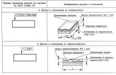
The calculated values of the design marks, slopes (in thousandths), the depth of the pipes and the distances are recorded in the corresponding columns of the grid of the longitudinal profile (see Fig. 3) and draw a design line on the profile.
On the cross-sectional profile (see Fig. 4), draw a trench section, taking the width of the trench bottom equal to 1 m, and the slope coefficient equal to 1.
4.3. Construction of the design profile of the highway.
Technical requirements for the design line of the highway.
The choice of the position of the route of the projected road on the longitudinal profile is due to the fulfillment of a number of requirements of a technical and economic nature. These include in particular:
Observance of limit slopes depending on the category of the road;
Ensuring the minimum volume of earthworks, maintaining their approximate balance, that is, the equality of the volumes of embankments and excavations;
Mandatory passage of the design line through the control points fixed in height;
The condition for the project line to cross the river.
The order of work on the construction of the design line of the road
Statement of the problem: according to the log of technical leveling of the route, the picket log, longitudinal and transverse profiles, design a section of the road from PK0 to PK6 with a length of 600 m.
The design elevation of the bridge crossing is 2-3 m above the spring water horizon (SWL);
Draw the design line of the bridge from PK2 to PK4 with a slope of 0.000;
The slope of the road from PK2 to PK0, equal to 0.030;
Road slope from PK4 to PK6, equal to 0.025.
Calculate:
The design level of the bridge crossing, adding 2-3 m to the GVV level;
Design marks on PK2, PK4 and all intermediate points between them, equal to the mark of the bridge crossing;
Design marks on PK1, PK0, PK5, PK6 and plus point PK4 + 42.0 for given slopes according to formula 2;
Working marks as the difference between the design marks and the ground marks, showing the height of the embankment or the depth of the excavation. Working elevations are calculated with an accuracy of 0.01 m and are signed vertically above the design line in the case of an embankment and below the design line in the case of a cut;
Distances to the points of zero work (points of intersection of the design line with the line of the earth profile) according to the formulas:
D1 = (| a | / (| a | + | b |))D D2 = (| b | / (| a | + | b |)) D,
where a and b are working marks at the nearest points of the profile;
D1 and D2 – distances to zero work points;
D is the distance between the points.
From the points of zero work, a dotted perpendicular is drawn to the line of the conditional horizon, and on both sides the vertically calculated distances from the points of zero work to neighboring points of the profile are recorded, rounded 0.1 m.
The calculated values of the design marks, slopes (in thousandths) and distances are written in the corresponding columns of the grid of the longitudinal profile (see Fig. 5) and draw a design line on the profile.
On the profile of the cross section (PK1, see Fig. 6), construct a cross section of the road, assuming the width of the road is 10 m, and the slope coefficient is 1. Above the design line of the road (PK1), record the working mark vertically.
Draw the longitudinal and transverse profiles with ink. First, in pale blue, make a hillshade of the mirror of water in the river on the plan and the section of the river on the profile, in pale red - embankments, in yellow - excavations. The design line is drawn in red ink, the axis of the route is on the plan. Columns design marks, slopes are filled in red. Work marks are also signed in red. The dashed perpendicular is shown in blue, lowered from the points of zero work to the line of the conditional horizon, and the distance from it to the nearest points of the profile. Green - coastlines, GMV and GVV marks; brown - river cliffs on the plan. The rest is outlined in black ink. Above the track profile, the position of the benchmarks is shown and the horizontal and vertical scales are signed. The heading "Longitudinal and transverse profiles of the route" should be placed in the stamp.
Building a plan of straight lines and curves of the road
At the turning points of the highway, its complex sections are joined by curves, most often circular, that is, arcs of a certain radius.
The breakdown of a circular curve is reduced to determining the picket position of its three points: the beginning (NK), the end (KK) and the middle (SK).
Statement of the problem: for two angles of rotation of the route θ (PK1+25.00 and PK4+90.18, see the picket log of the task for performing the survey) and the radius of the circular curve R=100 m, calculate the elements of the circular curve, calculate the picket position of its beginning and end, build a plan road axis elements. Order of execution:
1. For the given two angles of turn of the track θ and the radius of the curve R=100 m, calculate the elements of the circular curve (tangent T, curve K, bisector B, domer D) using the formulas:
T \u003d Rtg (θ / 2), K \u003d πR θº / 180º, B \u003d √ (T² + R²) -R, D \u003d 2T - K.
For example: θ= 57º 20", R=100 m, then T=54.67 m, K=100.07 m, B=13.97 m, D= 9.28 m.
2. Calculate the picket designation of the beginning and end of the curve for two angles of the route turn. For example:
VU1 PK1 + 25.00
- T 54.67
NK PK0 + 70.33
+ K 100.07
QC PK1 +70.40
- T 54.67
+D 9.28
Calculate the initial directional angle of the route from PK0 to VU1 PK1 + 25.00 according to the task for performing the GR. Then calculate the next directional angle from VU1 PK1 + 25.00 to VU2 PK4 + 90.18, adding to the initial directional angle the right turn angle along the way. Next, calculate the directional angle from VU2 PK4 + 90.18 to PK6, subtracting from the directional angle of the line VU1-VU2 the left along the direction of the turn of the route. Then convert the calculated directional angles into rhumbs.
According to the calculated data in the graph of the profile grid "Plan of straight lines and curves", build a plan of the elements of the road axis. The construction is done with red ink (see Fig. 5).
What is a pipeline route?
Longitudinal profile of the pipeline route.
Gas pipeline route- this is a line that determines the direction of the gas pipeline at each of its points. When drawing this line on the plans, it denotes the plan of the gas pipeline route, and its projection on a parallel plane is called the route profile. The choice of the pipeline route is called tracing. The gas pipeline route must take into account the condition of the minimum length of the network to the consumer. At the same time, the meeting points of gas flows are chosen at the boundaries of the hydraulic fracturing zones, and the condition of the impossibility of the return flow of gas in the hydraulic fracturing must also be observed.
GAS PIPELINE ROUTE
A line that defines its position in space. The projection of the gas pipeline route on the plan of the street or the area where it is laid is a plan of the gas pipeline route, and its projection on the turntable, the plane passing through the plan, is the longitudinal profile of the routes. Gas pipeline routes are chosen from the condition of transporting gas to consumers in the shortest way, achieving a minimum. length of gas pipelines. Gas pipelines of low and medium pressure are laid in technical lanes allocated for engineering networks along roads and mountains. passages parallel to the red building lines, high-pressure gas pipelines - in districts with low population density and along passages with low saturation of other underground utilities. Laying of gas pipelines along driveways with improvements. road surface, as well as parallel to electrified paths. railway Not recommended. To prevent damage to nearby ground and underground structures during the construction of gas pipelines and repair work on them, as well as to complicate the movement of gas when it leaks into buildings and communications, a minimum is set. the distance between them and the pipeline. Yes, min. the distance between the gas pipeline and the building in the light should be, m: at low gas pressure-2; with an average - 4; at high up to 0.6 MPa-7, at high up to 1.2 MPa - 10. Distances to tram and railway stations are also regulated. -d. ways, water supply and sewerage, heating networks and other structures. The most dangerous locations. near the gas pipeline, non-pressure communications (sewerage, drains, etc.), because through them, the escaping gas can spread over long distances and accumulate in basements, buildings and structures. Therefore, when designing, they consider the greatest distances from these communications. When crossing gas pipelines, Eng. networks, the distance between them in the light should be at least 0.2 m. Choice T.g. produced taking into account corrosion. activity of the pound and the presence of stray currents.
| | | next lecture ==> | |
PROJECT DOCUMENTATION SYSTEM
FOR CONSTRUCTION
GAS SUPPLY. OUTDOOR GAS PIPELINES
WORKING DRAWINGS
GOST 21.610-85
ST SEV 5047-85
USSR STATE COMMITTEE FOR CONSTRUCTION
Moscow
DEVELOPED by the Mosgazniiproekt Institute of the Fuel and Energy Sector Department of the Executive Committee of the Moscow City Council of People's Deputies
PERFORMERS
S. M. Zhdanov(topic leader) M.A. Maevsky, Yu. S. Besfamilny
INTRODUCED by the Executive Committee of the Moscow City Council of People's Deputies
Deputy Chairman of the Executive Committee of the Moscow City Council I. N. Ershov
APPROVED AND INTRODUCED BY Decree of the State Committee of the USSR for Construction of November 14, 1985 No. 195
STATE STANDARD OF THE UNION OF THE SSR
This standard applies to working drawings of external gas pipelines (underground, aboveground) for the transportation of natural, associated petroleum, artificial and mixed gases with an excess pressure of up to 1.2 MPa (12 kgf / cm 2) used as fuel and raw materials.
The standard establishes the composition and rules for the design of working drawings of external gas pipelines for construction projects in all industries and the national economy.
The standard fully complies with ST SEV 5047-85.
(Revised edition, Rev. No. 1).
1. GENERAL PROVISIONS
1.1. Working drawings of external gas pipelines are performed in accordance with the requirements of this standard and other standards of the Design Documentation System for Construction (SPDS), as well as the design standards for external gas pipelines.
1.2. The composition of the working drawings of external gas pipelines (the main set of working drawings of the GSN brand) includes:
general data on working drawings;
drawings (plans, longitudinal profiles) of gas pipelines.
The main set of working drawings of the GSN brand is made up of an equipment specification in accordance with GOST 21.110-82, a statement of the need for materials in accordance with GOST 21.109-80.
1.3. Gas pipelines in the drawings are indicated by conventional graphic symbols in accordance with GOST 21.106-78 and alphanumeric symbols in accordance with GOST 21.609-83.
If there are no visible sections of gas pipelines on the drawings, it is allowed to designate underground gas pipelines with a solid thick main line with the necessary explanations in the general data on the working drawings or on the corresponding drawings.
1.4. Conditional graphic designations of equipment, fittings, elements of gas pipelines, methods of laying gas pipelines are accepted according to the standards of the Unified Design Documentation System (ESKD) and according to the SPDS standards given in the reference appendix.
1.5. The diameter and wall thickness of the gas pipeline are indicated on the shelf of the leader line.
In the event that an alphanumeric designation of the gas pipeline is indicated on the shelf of the leader line, the diameter and wall thickness of the gas pipeline are indicated under the shelf of the leader line.
1.6. The scale of the images in the drawings must correspond to those given in the table.
2. GENERAL DATA ON WORK DRAWINGS
2.1. General data on working drawings are performed in accordance with GOST 21.102-79.
In the general instructions included in the general data on working drawings, in addition to the information provided for by GOST 21.102-79, they provide requirements for installation, testing, laying conditions, painting and insulation of gas pipelines.
3. PLANS OF GAS PIPELINES
3.1. For the development of plans for gas pipelines, working drawings of general plans, roads and railways, or topographic plans are used as a basis.
3.2. On the plans of gas pipelines apply and indicate:
existing and planned buildings (structures) in the form of simplified contour outlines with a solid thin line;
tying gas pipelines to the axes of the designed buildings (structures) or to the outer walls of existing buildings (structures);
engineering networks for other purposes, affecting the laying of the designed gas pipelines;
diameters and thicknesses of the designed gas pipelines before and after the points of their change;
picket numbers (PC);
structures on gas pipelines, for example, wells, condensate collectors, control and measuring points, electrical jumpers, insulating flange connections and electrical protection: cathodic, protective, electrical drainage.
On the plans of gas pipelines, if necessary, indicate the binding of elements of gas pipelines to the nearest pickets.
3.3. Gas pipeline plans may be placed both on separate sheets and together with the longitudinal profiles of gas pipelines.
An example of a gas pipeline plan is shown on.
Crap. 1
4. LONGITUDINAL PROFILES OF GAS PIPELINES
4.1. Longitudinal profiles of gas pipelines are depicted in the form of sweeps along the axes of gas pipelines.
4.2. On the longitudinal profile of the gas pipeline, apply and indicate:
the surface of the earth (design - with a solid thick main line, actual - with a solid thin line);
groundwater level (dash-dotted thin line);
crossed roads, railway and tram tracks, ditches, as well as other underground and above-ground structures in the form of simplified contour outlines - a solid thin line, communications that affect the laying of the designed gas pipelines, indicating their overall dimensions and elevations;
wells, carpets, overpasses, free-standing supports and other structures and structures of gas pipelines in the form of simplified contour outlines of external dimensions - by a solid thin line;
soil data;
pipe top marks;
trench depth from the design and actual ground surface;
cases on gas pipelines indicating diameters, lengths and their bindings to the axis of roads, structures that affect the laying of the designed gas pipelines, or to pickets;
drilling wells.
Gas pipelines with a diameter of 150 mm or less are allowed to be depicted in one line.
4.3. Under the longitudinal profile of the gas pipeline, a table is placed for underground laying of the gas pipeline and for above-ground laying.
It is allowed, if necessary, to supplement the tables with other lines, for example, “Soil characteristics: subsidence, swelling”, “Corrosivity”.
4.4. The bottom marks of the trench for the gas pipeline are put down at characteristic points, for example, at intersections with roads, railways and trams, utilities and structures that affect the laying of the designed gas pipelines.
The level marks are indicated in meters with two decimal places, the lengths of gas pipeline sections are in meters with one decimal place, and the slopes are in ppm.
4.5. The accepted scales of the longitudinal profiles are indicated above the side of the table.
An example of the design of a longitudinal profile of a gas pipeline is shown in.
Crap. 2
PAPPENDIX
Reference
LIST OF STANDARDS FOR SYMBOLS TO BE CONSIDERED WHEN CARRYING OUT DRAWINGS OF OUTDOOR GAS PIPELINES
|
Standard designation |
Name of the standard |
|
ESKD. Conditional graphic designations in schemes. General purpose symbols |
|
|
ESKD. Symbols are catchy graphic. Elements of hydraulic and pneumatic networks |
|
|
ESKD. Conditional graphic designations. Piping elements |
|
|
GOST 2.785-70 |
ESKD. Conditional graphic designations. Pipe fittings |
|
GOST 2.786-70 |
ESKD. Conditional graphic designations. Elements of sanitary devices |
|
GOST 21.108-78 |
SPDS. Conditional graphic images and symbols on the drawings of master plans and transport |
We build the profile of the underground gas pipeline from the point of insertion into the PK0 street network to the entrance to the residential building. According to SNiP 41-01-2002, the intra-quarter gas pipeline must be laid with a slope of at least: 1) 2‰ towards the street main, for dry gas; 2) 3 ‰ for wet gas.
If, in accordance with the terrain profile, it is impossible to lay the entire gas pipeline with a slope towards the street main, then at the point (PK ... +) the gas pipeline is kinked towards the street network with a slope of 2 ‰. The rest of the network is laid parallel to the terrain with a calculated slope (with installation of condensate collectors at low points).
The depth of the gas pipeline is determined depending on the type of gas, d of the gas pipeline, the depth of soil freezing, the geological structure of the soil and the type of road surface.
According to SNiP 42-01-2002 clause 5.2.1. laying of gas pipelines should be carried out to a depth of at least 0.8 m to the top of the gas pipeline.
Clause 5.6.4 The depth of laying gas pipelines in soils of varying degrees of heaving, as well as in bulk soils, should be taken up to the top of the pipe - not less than 0.9 of the standard freezing depth, but not less than 1 m.
With uniform heaving of soils, the depth of laying the gas pipeline to the top of the pipe should be:
not less than 0.8 of the standard freezing depth (0.8N pr), but not less than 1.0 m for strongly and excessively heaving soils.
Since the gas pipeline transports dried gas and is located:
in heavily heaving soils.
H o \u003d 1 + H pr + d (2.14)
but not less than 1.0 m to the top of the pipe.
H pr - depth of soil freezing for a given design area, m.
d is the maximum network diameter, m.
When designing the profile of the gas pipeline route, one should strive to ensure that the depth of the gas pipeline is close to optimal.
H 0 \u003d 1 + 0.090 + 0.2 \u003d 1.29 m.
In accordance with the terrain profile, we divide the entire route into sections with their own slopes of the bottom of the trenches. At the key points of these sections, we set the optimal depth of the gas pipeline.
We determine the elevation of the bottom of the trench at these points.
Z days n \u003d Z s.f .. n. - H o (2.15)
Z days k \u003d Z z.f .. k. - H o
Z days n, Z dn.tr. k, - marks of the bottom of the trench at the beginning and end of the section, m.
Z s.f. n. , Z s.f. k, - ground surface marks at the beginning and end of the section, m.
Z days PC0 = Z z.f. PK0 - H about
Z days PC0+N = Z z.f. PC0+N - H 0
Z days PC0 \u003d 77.38-1.29 \u003d 76.09 m;
Z days PC0 + 76.54 \u003d 77.05-1.29 \u003d 75.76 m.
We determine the slopes of the bottom of the trench by sections:
i \u003d (Z dn.tr. n - Z dn.tr. k) / l account * 1000 (2.16)
l uch - the length of the calculated section, m.
i \u003d (76.09-75.76) / 76.54 * 1000 \u003d 4.3‰.
The depth of the gas pipeline at intermediate points is determined as follows:
a) Determine the marks of the bottom of the trench at intermediate points:
Z days (n + 1) \u003d Z dn.tr.k ± ((i * l 1) / 1000) . (2.17)
Z days (n + 2) \u003d Z dn.tr.k ± ((i * l 2) / 1000)
l 1, l 2 - distance from the beginning of the section to the calculated point, m
Z days (PC0 + 76.54) \u003d 76.09 + (7.6 * 2.4) / 1000 \u003d 76.01m;
Z days (PC1 + 36.95) \u003d 75.62 + (3.7 * 2.2) / 1000 \u003d 75.6 m.
b) Determine the depth of laying:
H (n + 1) \u003d Z z. (n+1) - Z dn.tr. (n+1) (2.18)
H (PK0 + 76.54) \u003d 77.05-75.76 \u003d 1.29m;
H (PK1) = 76.91-75.62 = 1.29m.
Determine the top of the pipe:
Z in tr. = Z dn.tr. + w + h post (2.19)
Z days PC0 \u003d 76.09 + 0.090 \u003d 76.18 m;
Z days (PK0+22.5) = 75.76+0.090=75.85m;
Detailed calculation in Appendix B.
Similarly, all intermediate points on each section are calculated. In this case, the laying depth at all intermediate points should not be less than H o.